This is a follow-up to my I-90 coast-to-coast route and U.S. Route 20-coast-to-coast route, although this highway begins and ends just inland of each seaboard, running through the lower third of the country.
The route is meant to be followed VFR, and the two file options are mentioned below, where there is also a link to the route in SkyVector.
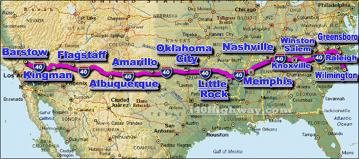
We are flying east from Barstow, California (Depue; 6CA8) to Wilmington, North Carolina (Wilmington International; KILM) above the 2,560-mile-long Interstate 40. This route, by air, is 2,206 miles / 3,550 km (1,917 nm) and stops in or flies over eight states: California, Arizona, New Mexico, Texas, Oklahoma, Arkansas, Tennessee and North Carolina. Route 66 is followed for part of the trip.
The leg safe altitudes range from 5,000 feet in the beginning stages, climbing to 9,000 feet through Arizona and New Mexico, then back down to 5,000 feet or lower for the remainder of the journey.
I have default scenery for every airport except Flagstaff (available for free here), Albuquerque (here), Asheville Regional (here), Burlington-Alamance (here) and Johnston Regional (here).
I’ve included the flight plan in both MSFS (.pln) and Little Navmap (.lnmpln) formats. To view it on SkyVector, click here.
There are 27 legs (for an average of 71 nm per leg).
Happy flying!

 newtestleper


Great work; thanks!
2 years ago
PUA687
Nice, thank you.
2 years ago
fStopper